
Characterize hazardous vegetation near the tracks
8,000 hours of train delays and an annual budget of 120 million euros: that's the burden that vegetation represents for SNCF Réseau.
|
Customer needs |
Optimize vegetation maintenance operations |
|
|
Types of data analyzed |
3D LiDAR point clouds |
|
|
Data acquisition method |
ESV measurement train |
|
|
|
1 |
Analysis of slope and soil inclinations |
| 2 |
Classification of slope and soil inclinations |
|
| 3 |
Classification of different areas around the tracks (cuttings, embankments, buffer zones, surroundings) |
|
|
Method of using the digital twin |
4 |
Analysis of vegetation heights (low, medium, high) |
|
|
5 |
Detection of vegetation close to the catenary (immediate danger within one meter) |
|
|
6 |
Modeling of tree falls |
|
Benefits for the client |
|
|
|
What is LiDAR ? |
|
LiDAR, which stands for "Light Detection and Ranging" or "Laser Imaging Detection and Ranging," is a distance measurement technique based on the analysis of the properties of a light beam returned to its emitter. A LiDAR system is an optoelectronic device consisting of a laser emitter, a receiver with a light collector (such as a telescope or other optics), and a photodetector that converts light into an electrical signal. It also includes an electronic signal processing chain that extracts the desired information. LiDAR data collected forms a three-dimensional point cloud with up to 7,000 points per square meter, providing a highly detailed and precise level of information. |
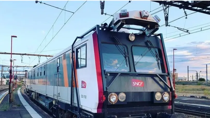
What is a Track Inspection Vehicle (TIV) ?


 Contact us!

.webp?width=51&height=51&name=acquisition%20(1).webp)
