
Verify the compliance of ballast profiles
Ballast maintenance and adjustment operations are crucial for the stability and longevity of the track, and they represent a significant portion of expenses for SNCR Réseau.
For instance, in 2019, expenditures in this area amounted to €67 million, with €61 million directly related to these operations.
|
Customer need |
Ensure track stability and reduce costs associated with ballast usage |
|
|
Types of data analyzed |
3D LiDAR point clouds |
|
|
Data acquisition method |
ESV measurement train |
|
|
Method of using the digital twin |
1 |
Rail extraction : vectorization of the traveled track |
| 2 |
Processing of 3D point clouds using Artificial Intelligence algorithms |
|
| 3 |
Compliance study of ballast quantity by comparing the theoretical level with the actual measured level on the shoulder profile, the cribbing, and the track bed |
|
|
Benefits for the client |
|
|
|
What is LiDAR ? |
|
LiDAR, which stands for "Light Detection and Ranging" or "Laser Imaging Detection and Ranging," is a distance measurement technique based on the analysis of the properties of a light beam returned to its emitter. A LiDAR system is an optoelectronic device consisting of a laser emitter, a receiver with a light collector (such as a telescope or other optics), and a photodetector that converts light into an electrical signal. It also includes an electronic signal processing chain that extracts the desired information. LiDAR data collected forms a three-dimensional point cloud with up to 7,000 points per square meter, providing a highly detailed and precise level of information. |
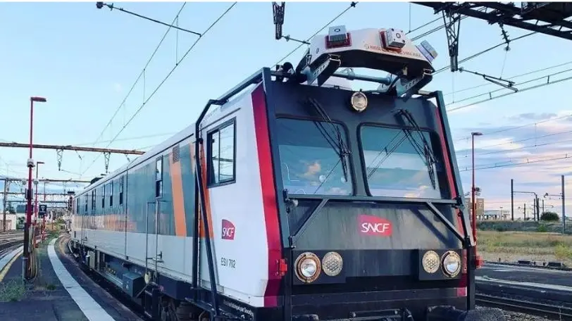
What is a Track Inspection Vehicle (TIV) ?


 Contact us!

.webp?width=51&height=51&name=acquisition%20(1).webp)
